Day 23: Sunday, September 7
/
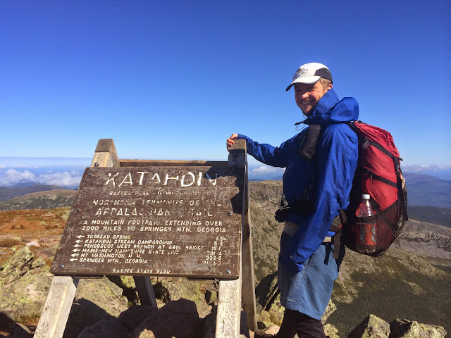
Finished the AT today at Katahdin (AT mi 2181.0*), walked 10.4 miles today
Woke up in the dark at 4:30 and by 5 had gotten all packed up and made my way down the street to the cafe. The early-bird crowd was me, some old Mainer guys who I got the sense were regulars at that hour, and a family of four who looked like they might be hiking. After discerning that they were indeed hiking, and that they were going up Katahdin via the Hunt Trail/AT, same as me, they were kind enough to offer me a ride into the park. They were Tyler and Nicki and their two kids, Jensen and (ahh I forget the boy's name, sorry dude, I know you're probably reading this), they were from downeast Maine, and they were total rockstars. We got to the trailhead around 6:45, along with a few dozen other people--7 a.m. is the cutoff for the parking lot so it creates a herd of day-hikers leaving at the same time--at which point the car thermometer only read 44 degrees.
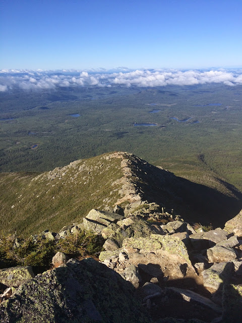
Left them and got going by 7:00 for the climb, 5.2 miles and 4150 feet of elevation gain, most of which is squeezed into the middle 3 miles. Passed most people in the first hour, though I was passed three times myself by thru-hikers going absurdly fast, each with focus etched into their faces and a disinclination to make conversation. The middle three miles, the ones with all the action, were a ton of fun, especially once the trail got above treeline. All of a sudden it got Arctically cold and dry-windy--I was freezing my ass off despite exerting myself uphill and in my rain jacket, hood cinched up so I could barely see, and tights--and the hike stopped becoming a hike and turned into a full-body boulder scramble for about an hour. The weather could not have been clearer and sharper, or the vistas greener and bluer, and I was alone for most of this time. Eventually I reached the false summit, called the Gateway, which I was wise to already from the maps, then enjoyed a calm final mile and a half over the flatter rocky alpine zone called the Tableland. Made the real summit just before 10 and there were only six people there: a thru-hiker, a dude named Richard from Utah, and four yuppie types. Only one of the latter responded to my request for assistance in taking a summit photo; she took just one, then silently handed my phone back to me and went back to smoking pot with her friends. Luckily, Richard was more alert to the personal significance of the moment and helped me get many more pictures. He and I talked for a few minutes, more people started trickling in, including Dortmund Joe and Eastwood, and by that point I was cold and it was time to get down, as I had nothing more to do or say to anyone up there.
I really felt immense happiness when I first got to the summit and the sign and I just plopped down leaning against it, as I'd always imagined I'd do; I don't remember nearly the same intensity of feeling getting to the monument at the end of the PCT. But the PCT happened more quickly, cleanly and confidently for me than the AT, which was stretched over three years during which I couldn't say to myself or anyone else that I'd hiked the whole thing, only part of it. I'd spent a lot more time visualizing the final moment when I'd get to the Katahdin sign than I had with the PCT monument, and a lot more time wondering how long I'd have to wait for it to happen. So to get up there on a perfect day, after a really enjoyable time in the 100 Mile Wilderness, with all aspects of planning pragmatically executed (and I get perhaps inordinately self-satisfied with the last one), left me quite chuffed. I stuck around on the summit as long as the warm glow lasted, but as soon as that was gone I knew there was no need to drag out my time and I had a practical concern to attend to, namely figuring out how to get 240 miles south by the evening.
Enter Eric and Laura, a couple I had overheard on the summit saying they were driving back to Boston today; I passed them on the descent and asked if I couldn't accompany them as far as Portland. Much like with the family I asked this morning, they agreed with no hesitation, and later refused gas money. Ended up getting back to the trailhead about ten minutes before them--descending through the rock scrambles was just as fun as coming up, although my knees were starting to hurt. They/I took off for the south lands right away, stopping only so I could get a bite to eat at the WacArnold's on the way out of Millinocket. Three hours later I was being dropped off at a Starbucks in Falmouth, near Portland, and a pumpkin-spiced hour after that A-GAME and her man Steve completed the handoff by picking me up there in their car and taking me to their place on the east side of Portland. After a fine home-cooked veggie pasta meal and a lot of conversation, we were all pretty well whupped--they'd had a ridiculously busy weekend and I'd been up since before dawn--so that was that and I repaired to my futon, where I will sleep like a fat lion tonight. Hiking is now over for the time being and the journal will stop being regular, but I plan to significantly update the rest of the webpage and keep the blog more alive than dead over the winter months. Especially if I give in to Carrot, Spark &co. and make moves toward the CDT next year. Ttfn.
*All my mileage figures have been from the 2011 AT Guide by AWOL. I think the official total mileage of the trail in 2015 is 2185 or something like that. Regardless of the big numbers, I'm confident I got the small numbers, i.e. how far I walked each day between points, right the whole time.
More pictures on Instagram: http://www.instagram.com/scrubhiker


